Wang Yuanyuan, Min Wenbin. MODIS/LST product validation for mixed pixels at Linzhi of Tibet. J Appl Meteor Sci, 2014, 25(6): 722-730.
Citation: Wang Yuanyuan, Min Wenbin. MODIS/LST product validation for mixed pixels at Linzhi of Tibet. J Appl Meteor Sci, 2014, 25(6): 722-730.

MODIS/LST Product Validation for Mixed Pixels at Linzhi of Tibet

  • Received Date: 2014-04-24
  • Rev Recd Date: 2014-09-09
  • Publish Date: 2014-11-30
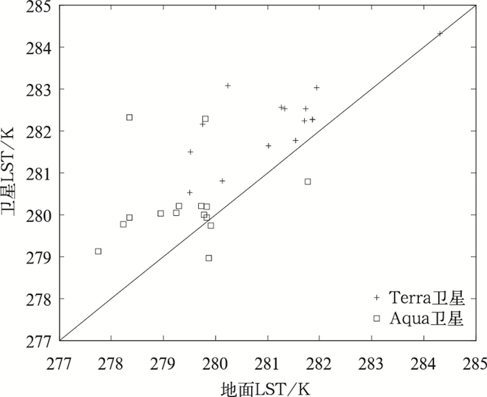
  • Southeastern part of Tibet is featured with complicated terrain and diverse land cover types. Validation of MODIS/LST product (1-km spatial resolution) in this region is faced with mixed pixel issue. Point-based LST measurements cannot represent the pixel well. To obtain ground LST measurements at pixel scale, traditional method usually depends on the high spatial resolution of thermal images, such as Aster and TM. However, these data are often unavailable due to persistent cloud cover and long repeat cycle. Therefore, a new simple method called area-weighted average (AWA) method is proposed, in which land cover map at high spatial resolution is combined with multi-site field observations to model the hypothetical observations at moderate pixel scale. The assumption of AWA method is that field observations can be shared within the same land cover. The AWA method is applied and analyzed on the case of Linzhi (with an area of 20 km2) which locates in southeastern part of Tibet. First, 5 field stations are set up on 5 typical land covers: Grassland, farmland, floodplain, forest at sunny slope, and forest at shadowy slope. The upward and downward long-wave radiations are measured simultaneously. Then the land cover map at 30 m spatial resolution is derived from TM image using maximum likelihood classification method. For every 1-km MODIS pixel, the fraction of each typical land cover is calculated, and the radiation at MODIS pixel-scale is estimated through area-weighted averaging. The broadband emissivity is calculated using linear combination of narrowband emissivity of MODIS band 31 and 32. Finally, LST at MODIS pixel-scale can be calculated based on Stefan-Boltzmann law. The AWA method is used for validating daily product of MODIS/LST from Terra and Aqua platforms on 10 June 2013 (LST at night is used because it changes slowly both in temporal and spatial domain). Results show that the RMSE of MODIS/LST is below 1.4 K (n=30) when applying the AWA method. If a point-based measurement is used to directly represent a MODIS pixel, the RMSE is more than 2.2 K (n=10), showing a tendency of over-estimation. The error of Aqua LST is slightly greater than that of Terra LST, probably due to a larger sensor view zenith angle during overpass. Superiority of the AWA method is more noticeable for pixels with high land cover heterogeneity and gentle terrain. The difference in LST between satellite and field observations can be decreased from 3 K to 1 K. However, for pixels with homogeneous land covers or with very tough terrains, the advantage of AWA method is limited. To further improve the AWA method, terrain adjustment should be taken into account when extrapolating point-based measurements to the same land cover but from another region, because the slope and aspect will influence the surface energy balance process even when the land cover stays the same. Results also indicate MODIS/LST data at nighttime in Linzhi Area are accurate, which are very meaningful considering the low density of meteorological stations in this area.
  • Fig. 1  The false color composite image of the study region

    (with an area of 20 km2, blue stars denote field experiment stations, numbers denote corresponding stations, white box denotes the MODIS pixel of 1 km)

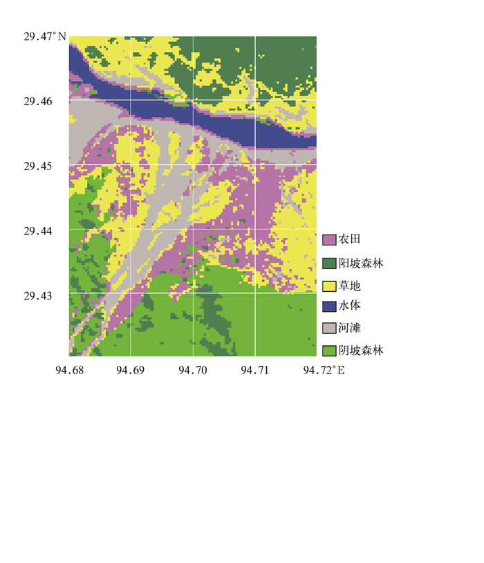
    Fig. 2  Land cover classification map derived from TM image with 30 m spatial resolution

    Fig. 3  Comparison of MODIS/LST with field LST measurements obtained with AWA method for the study region

    Table  1  Information summary of observation stations

    站点信息 农田站点 阴坡林地站点 草地站点 河滩站点 阳坡林地站点
    纬度 29.4459°N 29.4502°N 29.4487°N 29.4589°N 29.4685°N
    经度 94.6980°E 94.6859°E 94.6914°E 94.6947°E 94.7006°E
    高程/m 2939 3022 2965 2904 3166
    坡度/(°) 16.9 21.7 2.5 15.5 32.7
    坡向/(°) 356.5 105.5 343.7 235.8 212
    辐射计距地面距离 距农田地面1.7 m 距冠层1.5 m 距地面1.5 m 距地面1.6 m 距离冠层1.2 m
    DownLoad: Download CSV

    Table  2  Fraction occupied by each land cover type in the study region (with an area of 20 km2)

    土地覆盖类型 比例/%
    农田 17.73
    阴坡森林 21.91
    草地 24.35
    河滩 15.21
    水体 6.21
    阳坡森林 14.58
    DownLoad: Download CSV

    Table  3  Fraction occupied by each land cover type for the pixel of 1 km where the observation station locates

    土地覆盖类型 农田覆盖比例/% 阴坡森林覆盖比例/% 草地覆盖比例/% 河滩覆盖比例/% 阳坡森林覆盖比例/% 水体覆盖比例/%
    农田站点像元 35.27 16.34 13.55 32.69 2.15 0
    阴坡森林站点像元 21.93 36.67 40.54 0.86 0 0
    草地站点像元 10.75 0 36.02 53.12 0.11 0
    河滩站点像元 14.95 1.61 25.81 32.04 0 25.59
    阳坡森林站点像元 0 0 8.90 3.11 87.99 0
    DownLoad: Download CSV

    Table  4  Terrain index and standard deviation of slope for the pixel of 1 km with the observation station located

    像元类型 地形起伏度/m 坡度标准差/m
    农田站点像元 148 7.75
    阴坡森林站点像元 209 10.13
    草地站点像元 85 4.99
    河滩站点像元 118 8.98
    阳坡森林站点像元 617 6.64
     注:地形起伏度的定义是一定范围内最高海拔和最低海拔之差。
    DownLoad: Download CSV

    Table  5  Upward and downward long wave radiation measurements of each observation station obtained at satellite overpass time (unit:W·m-2)

    站点类型 Terra卫星过境时刻 Aqua卫星过境时刻
    上行长波辐射 下行长波辐射 上行长波辐射 下行长波辐射
    农田站点 338.6 263.8 330.1 261.7
    阴坡森林站点 356.2 259.0 345.9 257.0
    草地站点 344.8 249.1 336.4 249.1
    河滩站点 367.2 248.8 354.9 248.9
    阳坡森林站点 355.8 252.2 346.3 255.8
    DownLoad: Download CSV

    Table  6  Comparison of Terra MODIS/LST observations with field LST measurements, including AWA (area-weighted average) method and point-based method

    像元类型 LST/K Terra卫星发射率
    面积加权法 单点法 MOD11A1产品
    农田站点像元 281.01 278.23 281.64 0.9843
    阴坡森林站点像元 280.24 281.92 283.08 0.9803
    草地站点像元 281.95 279.67 283.02 0.9793
    河滩站点像元 284.31 284.31 284.32 0.9733
    阳坡森林站点像元 281.74 281.87 282.52 0.9803
     注:河滩1 km像元内有约25.59%的水体,因为没有水体上方的辐射观测值,无法基于面积加权法计算LST,故采用单点法计算的LST代替。
    DownLoad: Download CSV

    Table  7  Comparison of Aqua MODIS/LST observations with field LST measurements, including AWA (area-weighted average) method and point-based method

    像元类型 LST/K Aqua卫星发射率
    面积加权法 单点法 MYD11A1产品
    农田站点像元 278.95 276.44 280.02 0.9851
    阴坡森林站点像元 278.35 279.84 279.92 0.9803
    草地站点像元 279.84 277.94 279.92 0.9783
    河滩站点像元 281.77 281.77 280.78 0.9773
    阳坡森林站点像元 279.80 279.93 282.32 0.9803
    DownLoad: Download CSV
  • [1]
    Wang W H, Liang S L, Meyers T.Validating MODIS land surface temperature products using long-term nighttime ground measurements.Remote Sens Environ, 2008, 112:623-635. doi:  10.1016/j.rse.2007.05.024
    [2]
    周纪, 李京, 张立新.针对MODIS数据的地表温度反演算法检验——以黑河流域上游为例.冰川冻土, 2009, 31(2):239-246. http://www.cnki.com.cn/Article/CJFDTOTAL-BCDT200902009.htm
    [3]
    王圆圆, 李贵才, 张艳.利用MODIS/LST产品分析基准气候站环境代表性.应用气象学报, 2011, 22(2):214-220. doi:  10.11898/1001-7313.20110210
    [4]
    Keramitsoglou I, Kiranoudis C T, Ceriola G, et al.Identification and analysis of urban surface temperature patterns in Greater Athens, Greece, using MODIS imagery.Remote Sens Environ, 2011, 115:3080-3090. doi:  10.1016/j.rse.2011.06.014
    [5]
    Mildrexler D J, Zhao M S, Running S W.A global comparison between station air temperature and MODIS land surface temperature reveals the cooling role of forests.J Geophys Res, 2011, 116, G03025, doi: 10.1029/2010JG001486.
    [6]
    Wang Y Y, Li X, Tang S H.Validation of the SEBS-derived sensible heat for FY3A/VIRR and TERRA/MODIS over an alpine grass region using LAS.International Journal of Applied Earth Observation and Geoinformation, 2013, 23:226-233. doi:  10.1016/j.jag.2012.09.005
    [7]
    申双和, 赵小艳, 杨沈斌, 等.利用ASTER数据分析南京城市地表温度分布.应用气象学报, 2009, 20(4):458-464. doi:  10.11898/1001-7313.200904010
    [8]
    石涛, 杨元建, 马菊, 等.基于MODIS的安徽省代表城市热岛效应时空特征.应用气象学报, 2013, 24(4):484-494. doi:  10.11898/1001-7313.20130411
    [9]
    于敏, 程明虎.基于NDVI-Ts特征空间的黑龙江省干旱监测.应用气象学报, 2010, 21(2):221-228. doi:  10.11898/1001-7313.20100212
    [10]
    Wan Z, Zhang Y, Zhang Q.Quality assessment and validation of the MODIS global land surface temperature.Inter J Remote Sens, 2004, 25:261-274. doi:  10.1080/0143116031000116417
    [11]
    Coll C, Caselles V, Galve J M, et al.Ground measurements for the validation of land surface temperatures derived from AATSR and MODIS data.Remote Sens Environ, 2005, 97:288-300. doi:  10.1016/j.rse.2005.05.007
    [12]
    Wang K C, Liang S L.Evaluation of ASTER and MODIS land surface temperature and emissivity products using long-term surface longwave radiation observations at SURFRAD sites.Remote Sens Environ, 2009, 113:1556-1565. doi:  10.1016/j.rse.2009.03.009
    [13]
    高懋芳, 覃志豪.中国MODIS地表温度产品验证.国土资源遥感, 2006(3):15-18. doi:  10.6046/gtzyyg.2006.03.04
    [14]
    Liu Y B, Hiyama T, Yamaguchi Y.Scaling of land surface temperature using satellite data:A case examination on ASTER and MODIS products over a heterogeneous terrain area.Remote Sens Environ, 2006, 105:115-128. doi:  10.1016/j.rse.2006.06.012
    [15]
    Guillevic P C, Privette J L, Coudert B.Land surface temperature product validation using NOAA's surface climate observation networks—Scaling methodology for the Visible Infrared Imager Radiometer Suite (VIIRS).Remote Sens Environ, 2012, 124:282-298. doi:  10.1016/j.rse.2012.05.004
    [16]
    Wan Z, Dozier J.A generalized split-window algorithm for retrieving land surface temperature from space.IEEE Transactions on Geoscience and Remote Sensing, 1996, 34:892-905. doi:  10.1109/36.508406
    [17]
    吴晓, 陈维英.利用FY-1D极轨气象卫星分裂窗区通道计算陆表温度.应用气象学报, 2005, 16(1):45-53. doi:  10.11898/1001-7313.20050106
    [18]
    Snyder W, Wan Z, Zhang Y, et al.Classification-based emissivity for land surface temperature measurement from space.International Journal of Remote Sensing, 1998, 19:2753-2774. doi:  10.1080/014311698214497
    [19]
    Li H, Sun D L, Yu Y Y, et al.Evaluation of the VIIRS and MODIS LST products in an arid area of Northwest China.Remote Sens Environ, 2014, 142:111-121. doi:  10.1016/j.rse.2013.11.014
    [20]
    高登义, 邹捍, 王维.雅鲁藏布江水汽通道对降水的影响.山地学报, 1985, 3(4):239-249. http://www.cnki.com.cn/Article/CJFDTOTAL-SDYA198504007.htm
    [21]
    赵英时.遥感应用分析原理与方法.北京:科学出版社, 2003:197-198. http://www.cnki.com.cn/Article/CJFDTOTAL-HKJJ200104002.htm
    [22]
    Jin M L, Liang S L.An improved land surface emissivity parameter for land surface models using global remote sensing observations.J Cliamte, 2006, 19:2867-2881. doi:  10.1175/JCLI3720.1
    [23]
    Wang K C, Wan Z M, Wang P C, et al.Estimation of surface long wave radiation and broadband emissivity using Moderate Resolution Imaging Spectroradiometer (MODIS) land surface temperature/emissivity products.J Geophys Res, 2005, 110, D11109, doi: 10.1029/2004JD005566.
    [24]
    申彦波, 张顺谦, 郭鹏, 等.四川省太阳能资源气候学计算.应用气象学报, 2014, 25(4):493-498. doi:  10.11898/1001-7313.20140413
    [25]
    Vancutsem C, Ceccato P, Dinku T, et al.Evaluation of MODIS land surface temperature data to estimate air temperature in different ecosystem over Africa.Remote Sens Environ, 2010, 114:449-465. doi:  10.1016/j.rse.2009.10.002
  • 加载中
  • -->

Catalog

    Figures(3)  / Tables(7)

    Article views (2592) PDF downloads(873) Cited by()
    • Received : 2014-04-24
    • Accepted : 2014-09-09
    • Published : 2014-11-30

    /

    DownLoad:  Full-Size Img  PowerPoint